The cooler months are the perfect time to enjoy outdoor sports. Activities such as hiking are the perfect way to get some exercise, while at the same time recharging our energy with some fresh air. Whether you love inland mountain scenery, or you're more of a near-the-coast hiker, you'll find stunning scenery to explore on the Costa del Sol. Discover some of the best hiking trails in the province of Málaga below.
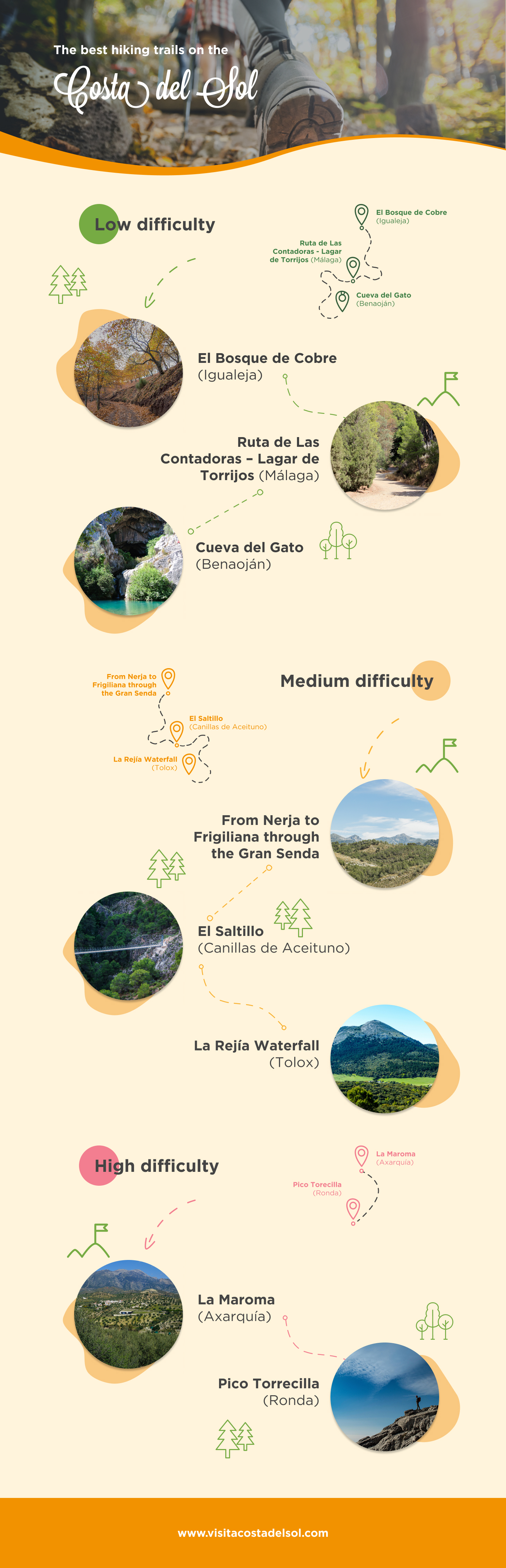
Low difficulty hiking trails
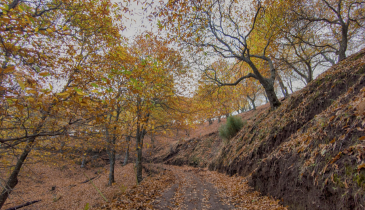
El Bosque de Cobre (Igualeja)
El Bosque de Cobre (The Copper Woods) owes its name to the reddish, brown and yellow tint its (chesnut) tree leaves turn to when autumn arrives. More than 15 municipalities make up the area, from the majestic city of Ronda, through picturesque villages such as Cartajima or Júzcar, known worldwide as 'La Aldea Azul' (The Blue Village) because of the colour of its buildings. But, specifically, this hiking trail runs through the municipality of Igualeja, where the source of the river Genal is located. From there we will set off along trails to the Charco de la Sal on a circular route of approximately 9 kilometres.
Las Contadoras - Lagar de Torrijos Trail (Málaga)
Just an hour from the centre of the capital of the Costa del Sol, we can enjoy the native flora and fauna in the Montes de Málaga Natural Park. There are countless hiking routes. On this post, we suggest the trail that connects the Aula de las Contadoras with the Lagar de Torrijos: a circular path of about 8 kilometres where you can see the ruins of the old buildings where vines were grown and treated in the 19th century. Until you reach the starting point, it is worth stopping at one of the viewpoints along the way up to enjoy the exquisite panoramic views of the city. And, to finish, there is nothing better than recovering your energy with a good mountain dish, or some migas in one of the typical "ventas" of Málaga.
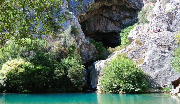
Cueva del Gato (Benaoján)
This trail is perfect for inexperienced hikers. The route starts at the train station in Benaoján, where you can easily park your car. From there, a 2.5 km path with hardly any gradient will take you to the Natural Monument of the Cueva del Gato. Although it is not accessible without authorisation, the path runs through really beautiful surroundings and, in summer, you can enjoy a swim in the Charco Frío, whose crystalline waters emanate directly from the Cueva del Gato.
Medium difficulty hiking trails
From Nerja to Frigiliana along the Gran Senda
The path that connects Nerja and Frigiliana along the Gran Senda de Málaga, which corresponds to stage 5 of this enormous network of routes, is an incredibly beautiful trail. This low-difficulty route stretches for 15 kilometres, and takes approximately five hours to cover. Although it is a medium-difficulty mountain route, the ruggedness of the terrain and the possibility of encountering changeable weather should not be underestimated.
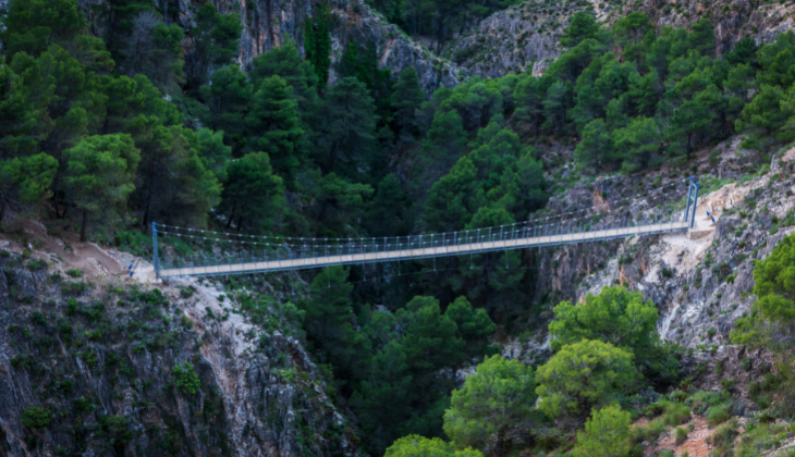
El Saltillo (Canillas de Aceituno)
Although its length, only four kilometres, would seem to suggest otherwise, the trail that leads to the El Saltillo suspension bridge offers a certain complexity. Not so much because of the slope, but because of its course, alongside high cliffs. In the heart of the Axarquía, this path offers one of the most attractive images of the province. You will take your first steps through orchards, from the town centre of Canillas de Aceituno, and continue along an irrigation channel. After going over a footbridge, the path zigzags down through a pine forest to the suspension bridge, 78 metres above the canyon of the river Almanchares. The route can end there or continue, five kilometres further, towards Sedella.
La Rejía waterfall (Tolox)
The Sierra de las Nieves National Park hides some truly unusual places. One of them is the La Rejía waterfall (Tolox), the largest in the province of Málaga. The trail starts next to the 'Balneario de Tolox', from where the path runs parallel to the river, crossing it several times and offering various opportunities to bathe in its pools on the hottest days. A couple of kilometres later you reach the so-called Charco de La Virgen. The path then begins to climb towards the La Rejía waterfall, where you will have to take precautions, as the path narrows. The route can be completed in a circular way along a pine grove or by turning back along the same path.
High difficulty hiking trails
La Maroma (Axarquía)
The summit of the province of Málaga is a challenge for many hikers. At more than 2,000 metres above sea level, the peak of La Maroma, in the region of La Axarquía, is the closest thing to a high mountain in the province. The route can be done from different points: Alcaucín, Canillas de Aceituno and Sedella from its south face, as well as from El Robledal (Alhama de Granada), on its north face. In all cases, the trail will take between seven and eight hours, with a continuous ascent, but we assure you that the effort will be well worth it once you reach your goal.
Torrecilla Peak (Ronda)
The Torrecilla Peak (1,919 metres above sea level) is one of the best known peaks in the Sierra de las Nieves National Park. We recommend starting the route in Los Quejigales, a recreational area in the town of Ronda. This trail, which lasts 6 hours, offers 7.5km through a forest rich in both flora and fauna.
Exploring new landscapes, enjoying nature and exercising in the open air are the great values of hiking. A healthy and fun activity for people of all ages and levels, discover the incredible natural landscapes that await you on the Costa del Sol and enjoy the best hiking trails with family or friends!

12 December 2022

